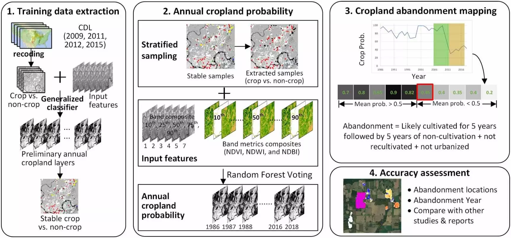
The battle against climate change often involves the use of farmland, where the production of food competes with the cultivation of energy crops and the installation of solar panels. Unfortunately, this clash can sometimes lead to harmful consequences, such as increased greenhouse gas emissions. However, there is hope on the horizon with the development of a new tool by scientists at the University of Wisconsin-Madison. Led by Yanhua Xie and Tyler Lark of the Great Lakes Bioenergy Research Center, this tool utilizes machine learning to map nearly 30 million acres of abandoned cropland in the United States since the 1980s. This mapping provides detailed information on lands that can potentially be used to grow crops for sustainable plant-based fuels, helping to mitigate climate change.
The Significance of Abandoned Cropland
One of the key findings of the study conducted by Xie and Lark is the identification of abandoned cropland that could be utilized for the cultivation of crops like switchgrass or sorghum. These crops have the potential to trap carbon in the soil, serving as valuable feedstocks for biofuels and substitutes for petrochemicals. By focusing on lands that were previously considered unprofitable or difficult to cultivate, researchers aim to tap into the hidden potential of these areas for sustainable energy production. Understanding the characteristics and locations of these abandoned lands is crucial for maximizing their impact on climate mitigation efforts.
Data Analysis and Mapping
The development of the tool using machine learning techniques allowed for the creation of detailed maps of abandoned cropland in the U.S. at a field-level resolution. This level of precision is unprecedented and provides valuable insights into the distribution and characteristics of these lands. The data generated by this analysis are publicly available in the Great Lakes Bioenergy Research Center’s interactive atlas of U.S. cropland, offering a resource for researchers and policymakers to make informed decisions regarding land use and energy production strategies.
The mapping of abandoned cropland not only reveals the extent of unused agricultural spaces but also presents opportunities for directing clean energy investments effectively. By identifying areas with the least competition for alternative uses, such as solar photovoltaic installations, agrivoltaics, or cellulosic bioenergy development, researchers can target these lands for sustainable energy projects. Moreover, the study highlights the potential for restoring natural ecosystems on abandoned cropland, further benefiting the environment and biodiversity.
While the mapping and analysis of abandoned cropland represent a significant step forward in sustainable energy research, there are still challenges to overcome. Understanding the drivers behind the abandonment of these lands will be crucial for planning future land use strategies. Incorporating socioeconomic data and tax records into the analysis can provide valuable insights into the decision-making processes of farmers and landowners. Additionally, future research may focus on modeling biomass production on abandoned lands and quantifying their capacity to sequester carbon dioxide from the atmosphere.
The utilization of abandoned cropland for sustainable energy production holds great promise in the fight against climate change. The innovative tool developed by researchers at the University of Wisconsin-Madison offers a groundbreaking approach to mapping and analyzing these lands, providing valuable data for future research and policy interventions. By harnessing the potential of these abandoned lands, we can take significant strides towards achieving a more sustainable and environmentally friendly energy landscape.


Leave a Reply