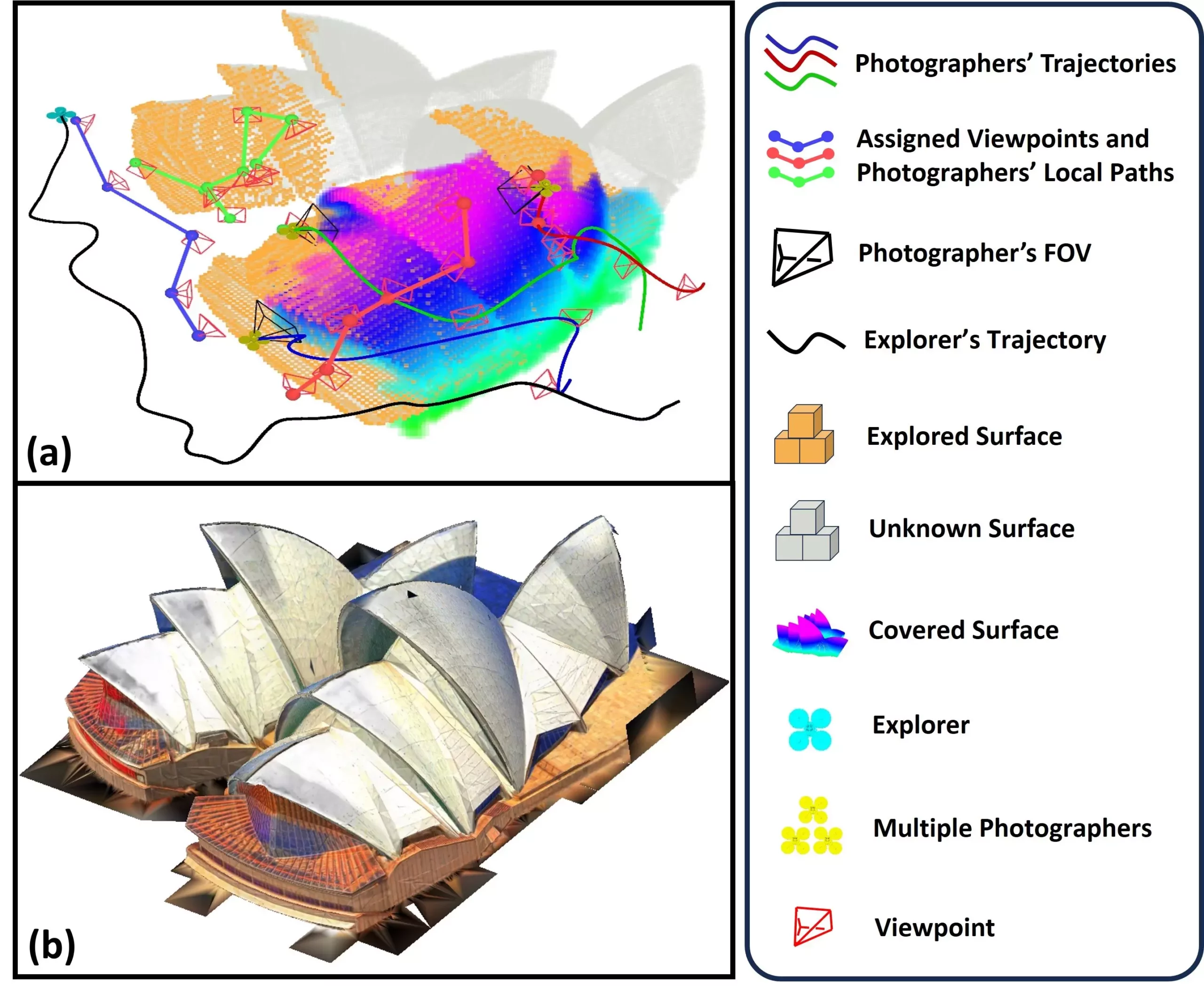
Unmanned Aerial Vehicles (UAVs), commonly known as drones, have transformed the landscape of environmental monitoring and exploration. These autonomous flying machines serve various purposes, ranging from simple aerial photography to complex data collection for scientific research. Their capability to construct detailed maps and three-dimensional (3D) representations of real-world environments is particularly noteworthy. A groundbreaking contribution to this field comes from researchers at Sun Yat-sen University and the Hong Kong University of Science and Technology, who recently unveiled a pioneering system named SOAR. Designed to facilitate rapid, autonomous environmental reconstruction, SOAR harnesses the power of a coordinated team of UAVs to explore, photograph, and reconstruct complex environments in real time.
The creators of SOAR recognized a growing demand for efficient and cost-effective solutions in 3D reconstruction using UAVs. According to Mingjie Zhang, a co-author of the study, existing methodologies predominantly fall into two categories: model-based and model-free techniques. While model-based methods often prove time-intensive and costly due to their dependence on pre-existing data, model-free approaches can struggle with local planning limitations. The SOAR system aims to harmonize these two methodologies, integrating their advantages while mitigating their shortcomings.
The researchers set specific goals: to develop a heterogeneous multi-UAV system capable of simultaneous exploration and photography, thus accumulating comprehensive data for reconstruction purposes. They undertook the challenge of creating an advanced viewpoint generation technique, which adapts to real-time scene data, alongside a task assignment strategy designed to enhance the operational efficiency of the UAV team.
The structure of SOAR revolves around its innovative use of a LiDAR-Visual heterogeneous approach. The UAV team is composed of a primary explorer equipped with LiDAR technology, responsible for swiftly surveying the environment, and multiple photographer drones tasked with capturing high-resolution images. The dynamic interplay between exploration and data collection is pivotal; as the explorer identifies surface features, the system concurrently generates optimal viewpoints for subsequent photographic capture.
The methodology employed in SOAR incorporates a surface frontier-based navigation strategy, which proves vital for efficient mapping. As the explorer charts the environment, the system produces viewpoints that guarantee comprehensive documentation of the physical landscape. Subsequently, the photographer UAVs employ a well-defined path-planning system using the Consistent-MDMTSP approach, ensuring tasks are evenly distributed and that efficiencies are maximized. This cooperative model enables UAVs to efficiently gather data that contributes to high-fidelity 3D reconstructions.
One of the standout features of SOAR is its dual-sensor capability, which allows for simultaneous data acquisition from both LiDAR and conventional visual sensors. This adaptability is crucial as it ensures not only efficiency in exploration but also a higher quality of the resultant reconstructions. The dynamic nature of the SOAR system allows it to modify its approach based on real-time scene information, striking an exceptional balance between coverage and viewpoint minimization.
The research team systematically evaluated SOAR through rigorous simulations, revealing that the system excels beyond conventional state-of-the-art methods in environmental reconstruction tasks. At the heart of SOAR’s success lies a suite of innovative algorithms designed to facilitate both rapid planning and effective data collection, resulting in a notably streamlined process.
The implications of SOAR’s technology extend into various areas that necessitate quick and precise 3D environmental assessments. Potential applications range from urban planning and infrastructure monitoring to cultural heritage preservation, disaster response, and even video game design. For instance, SOAR could significantly enhance disaster recovery efforts by facilitating quick damage assessments in the aftermath of natural calamities, thereby enhancing rescue and recovery operations.
Zhang envisions a future where SOAR could help preserve historic sites and artifact collections, enabling historians to maintain accurate records of cultural heritage. Furthermore, the platform’s unique capabilities could streamline the inspection process at construction sites, affording workers clear and comprehensive maps that ensure safety and efficiency.
The researchers have ambitious plans for SOAR’s development, focusing on closing the gap between simulated performance and real-world application. Key challenges include addressing localization inaccuracies and communication disruptions that might occur during field operations. To enhance the system’s capabilities, Zhang and his team aim to devise advanced task allocation strategies and integrate modules for scene prediction and information processing. These innovations could allow SOAR to dynamically anticipate environmental structures, thus expediting the mapping process.
Furthermore, the implementation of real-time feedback mechanisms during reconstruction tasks could result in a further increase in efficiency. Investigating the integration of factors such as camera angles and image quality directly into the planning algorithms will ensure that the collected visual data is optimized for creating stunning 3D reconstructions.
SOAR stands at the forefront of revolutionary advancements in UAV technology, with the potential to reshape various industries and improve countless processes through its innovative approach to environmental reconstruction. As ongoing research unfolds, the future looks bright for this cutting-edge system and its myriad applications.


Leave a Reply