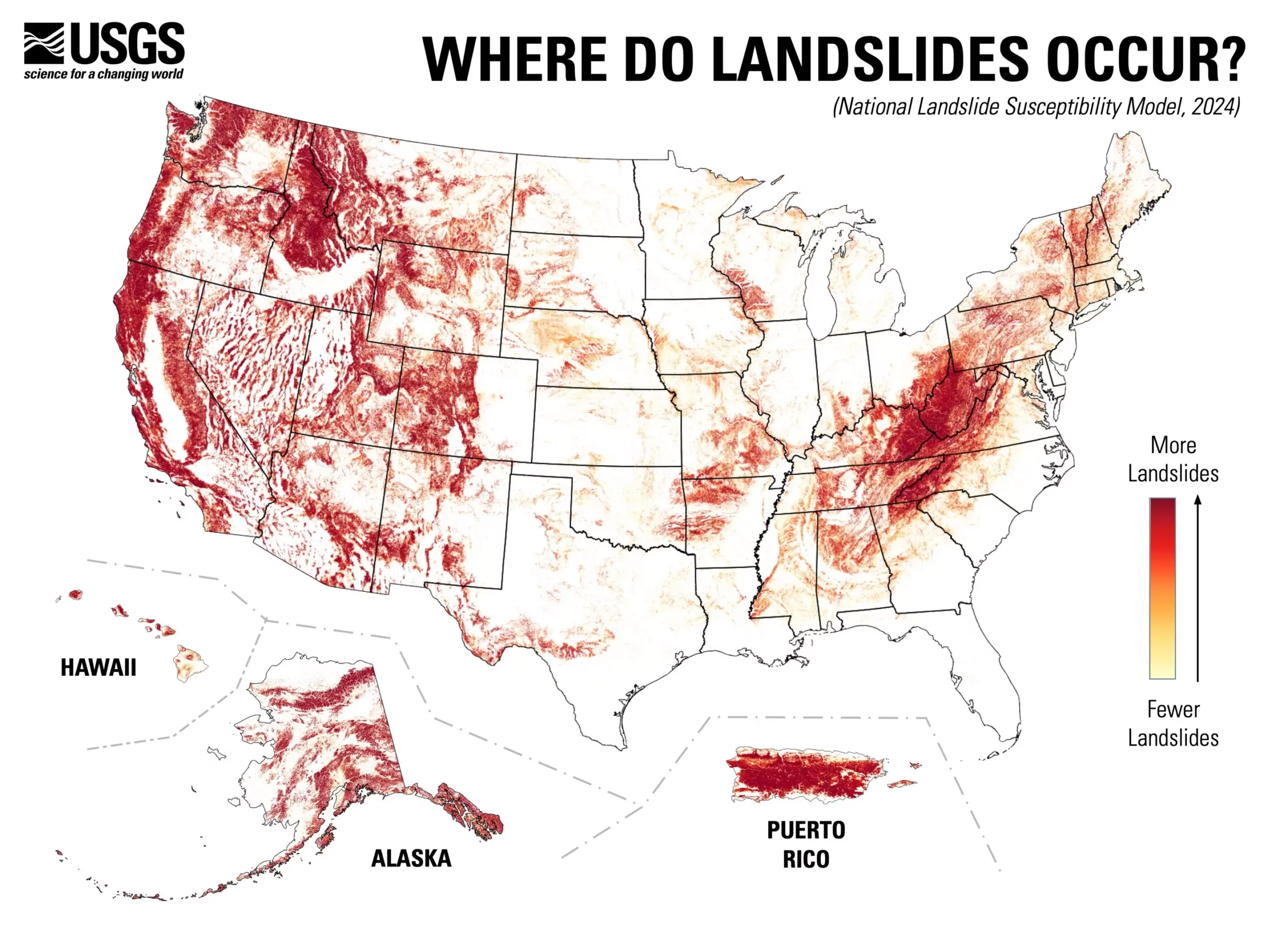
The recent release of a nationwide landslide susceptibility map by the U.S. Geological Survey (USGS) marks a significant advancement in understanding the potential risks posed by landslides across the United States. Approximately 44% of the nation faces some level of landslide susceptibility, a statistic that highlights the urgent need for awareness and preparedness in both urban and rural planning contexts. The detailed county-by-county assessment presented in the map serves as a crucial resource for professionals involved in land-use planning and disaster risk management.
The development of this map is rooted in a robust methodology involving extensive data gathering and advanced technological applications. To create this comprehensive model, scientists utilized an extensive inventory of nearly one million historical landslide incidents, coupled with high-resolution elevation data sourced from the USGS 3D Elevation Program. This powerful combination of historical data and cutting-edge computation allows for a nuanced understanding of geographical areas at risk, ultimately providing a more reliable predictor of landslide activity than previous maps.
The map’s high resolution sets it apart from earlier versions that mostly covered regions known for their high landslide risk. This innovation enables planners and engineers to pinpoint potential instability even in areas previously thought to be safe, making a compelling case for proactive measures in land-use decisions.
Implications for Land-Use Planning and Mitigation Strategies
The applicability of the new landslide susceptibility map extends beyond merely identifying risky areas. Land-use planners and policymakers can leverage this information to prioritize resource allocation for disaster mitigation efforts in vulnerable regions. The map illustrates where additional mapping may be warranted, thus streamlining the efforts to enhance overall geologic hazard readiness across the nation.
As Ben Mirus, a USGS research geologist, noted, “This map addresses an important but difficult question: which areas across the entire U.S. are prone to landslides?” The clarity this tool brings is essential for fostering a culture of awareness among communities that may otherwise be left unaware of the geologic challenges they face.
Moreover, the availability of this map symbolizes a progressive step toward creating a more hazard-ready environment for all Americans. With the potential for landslide occurrences ranging from insidious soil movements to catastrophic landslides triggered by heavy rain, communities can no longer afford to be complacent. The national map serves to bolster educational initiatives and inform the public about the risks associated with landslide occurrences. By promoting awareness and empowering stakeholders with reliable data, the USGS fosters a collaborative approach towards risk reduction.
The new landslide susceptibility map heralds a transformative era in hazard preparedness and land management. The data-driven insights it offers are invaluable for not only protecting lives but also preserving property and infrastructure from the disruptive impacts of landslides. As the nation contemplates urban expansion and infrastructure development, leveraging this sophisticated tool will play a critical role in cultivating safer communities for generations to come.


Leave a Reply