Wildfires present one of the most dangerous challenges to firefighters, compelling them to act swiftly and decisively when faced with a raging inferno. When flames leap over fire lines and threaten to engulf a crew, the stakes are elevated, and the need for efficient escape routes becomes paramount. For years, firefighters have depended heavily on their firsthand experience and situational assessments to navigate potentially treacherous terrain. This reliance often omits valuable digital inputs or aerial data, leading to outdated methodologies that inadequately address the complexities posed by diverse landscapes.
One of the traditional methods of estimating travel times across varying terrains accounted only for steepness. However, this approach fails to encapsulate the full scope of obstacles encountered in the field. For instance, traversing a steep road could be quicker than moving across flat, boulder-strewn ground or struggling through dense underbrush. The urgency for a comprehensive tool that could accurately evaluate the parameters influencing evacuation and traversal time is growing in various fields, from firefighting to disaster response, rural healthcare, and even archaeology.
In a groundbreaking study conducted by researchers at the University of Utah, the Simulating Travel Rates in Diverse Environments (STRIDE) model emerged as a response to this urgent need. STRIDE revolutionizes the assessment of travel times by integrating factors such as ground roughness and vegetation density alongside traditional slope steepness. It offers an innovative tool that promises to improve the safety and efficacy of escape routes for those in perilous situations, particularly in firefighting.
Mickey Campbell, the lead author of the study, emphasized the importance of mobility in critical situations when lives are at stake. By using airborne Light Detection and Ranging (LiDAR) technology, the STRIDE model draws on laser pulse data, producing precise three-dimensional maps of landscapes. This data allow researchers to create a remarkably straightforward yet precise equation that highlights the most efficient routes between virtually any two points, regardless of terrain type.
The development of STRIDE was not merely an academic exercise; it involved rigorous testing in real-world scenarios. The researchers analyzed existing LiDAR data while also conducting field trials, where volunteers traversed specified distances across various terrains. This real-life feedback provided insights into human movement dynamics, equipping the system to make more accurate predictions about travel time.
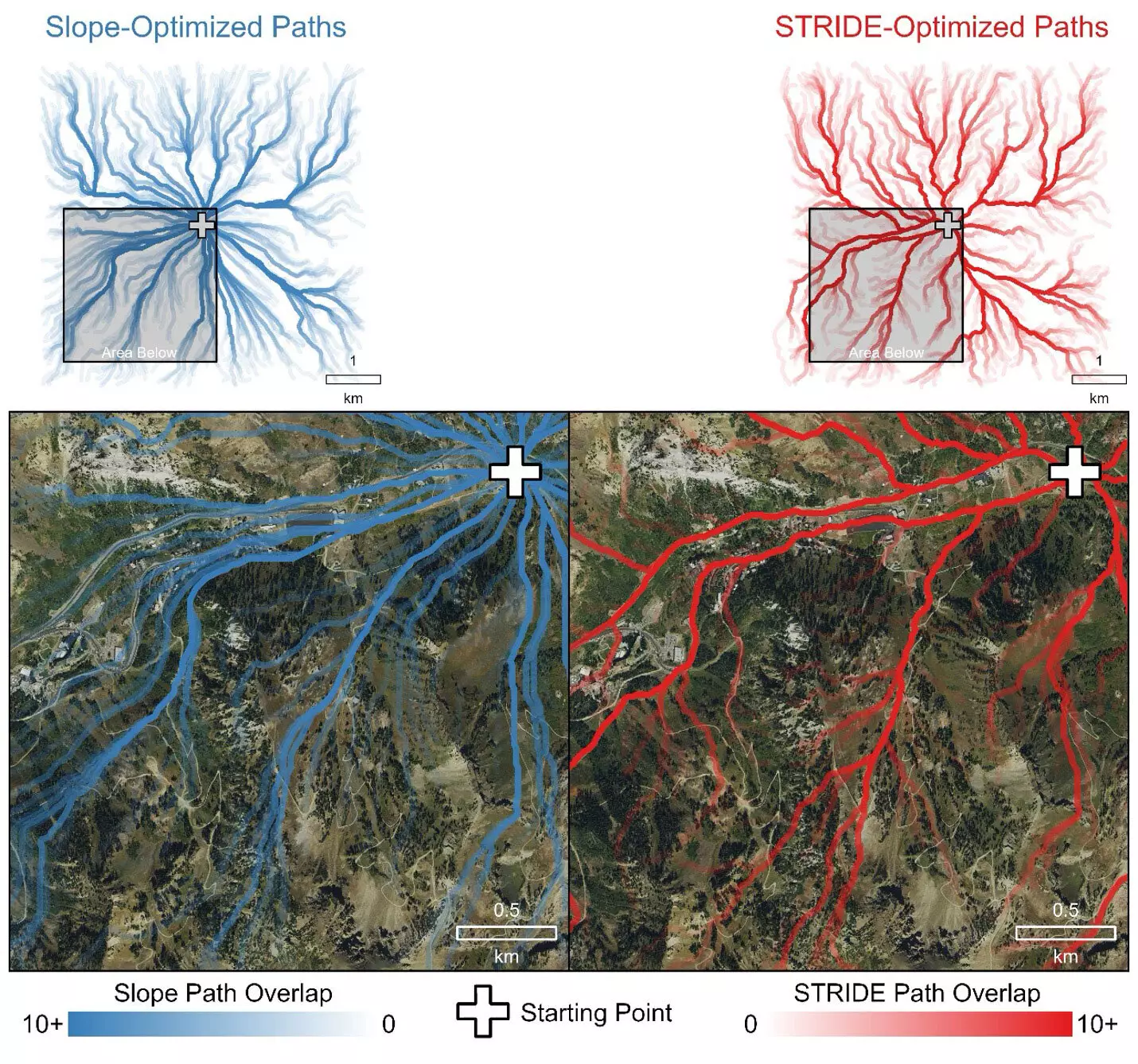
Initial field trials launched in 2016 encountered the challenge of limited LiDAR mapping in the western U.S. however, as LiDAR technology has become more accessible, the researchers’ ability to measure travel rates improved significantly. With the progression of the studies, clear patterns emerged, indicating STRIDE’s preference for paths that people would intuitively choose, such as established roads and trails.
A pivotal aspect of STRIDE’s validation was its comparison against the conventional slope-only model. STRIDE consistently outperformed this outdated paradigm by producing travel time estimates that were grounded in practical human experience rather than mere geographical gradients. In emergency scenarios, when every second counts, the implications of STRIDE’s predictive capabilities could be life-saving.
For instance, during simulated rescue operations for injured hikers, STRIDE demonstrated an innate understanding of geographical context, directing responders along roads and trails while avoiding denser vegetation and challenging landscapes. This intuitive route-finding ability sets STRIDE apart from its predecessors and underscores its potential impact in emergency preparedness and response.
The implications of the STRIDE model extend beyond the realm of firefighting. Its ability to evaluate pedestrian mobility opens doors to enhanced planning in numerous disciplines, including archaeology, outdoor recreation, and urban planning. By integrating vegetation and terrain analyses into navigation tools, we can create safer, more accessible environments while supporting various professional needs.
The practical applications could involve everything from disaster response scenarios to optimizing outdoor recreational pursuits. With the STRIDE model publicly accessible, professionals equipped with LiDAR data can adopt its insights to streamline operations and enhance safety margins across various sectors.
The increase in wildfire frequency and intensity calls for a reevaluation of our strategies in terms of emergency response and firefighter mobility. By leveraging the capabilities of the STRIDE model, we embark on a new frontier that prioritizes safety and efficiency. As researchers refine and expand these models, we can anticipate not only improved emergency response frameworks but an overall enhancement in our understanding of how landscapes impact mobility in various contexts. STRIDE is not just a tool but a critical advancement that can save lives and redefine how we approach safety in challenging environments.


Leave a Reply