Nitrogen dioxide (NO₂) is more than just a chemical compound; it’s a silent menace that drastically affects the air we breathe. Primarily emitted through anthropogenic activities—especially fossil fuel combustion in vehicles and power plants—this pollutant poses serious risks to our health and the environment. With a significant role in forming smog and contributing to respiratory ailments, the importance of comprehensively monitoring NO₂ levels cannot be overstated. It’s a pivotal element that not only taints the air quality but also influences climate patterns and the health of various ecosystems.
One of the chronic challenges in environmental science has been accurately mapping the sources and concentrations of NO₂. Historically, our reliance on satellite data has been hampered by coarse resolutions that made it ineffective for identifying specific emission sources like power plants. However, recent breakthroughs in satellite technology are turning the tide, offering unprecedented clarity and detail.
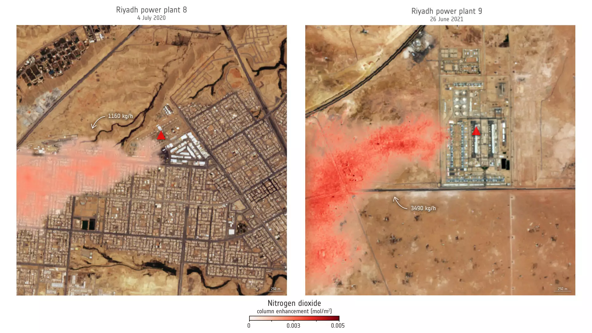
The ground-breaking research recently published in the *Proceedings of the National Academy of Sciences* ushers in a new era for air quality monitoring. By harnessing the power of the Copernicus Sentinel-2 and Landsat satellites, scientists are able to detect and analyze nitrogen dioxide emissions from individual sources, a feat that was largely unattainable with earlier technologies. The unparalleled spatial resolution of these satellites enables the precise observation of NO₂ plumes, marking a significant advancement in our understanding of urban air pollution.
This innovative application of remote sensing technology illustrates how satellites, originally designed for land and natural resource monitoring, can provide critical insights into air pollutants. Featuring high-definition images, the data retrieved allows researchers to focus on specific regions and discern even minute changes in nitrogen dioxide emissions, thus opening the door to a multitude of environmental studies.
The study focused primarily on power plants in the United States and Saudi Arabia, showcasing the real-world applications of this technology. The imagery gathered from key sites, such as a power plant in Riyadh and plants in Wyoming, revealed significant findings about emission trends related to power generation. For instance, a thorough analysis over a span of 13 years at Riyadh power plant 9 demonstrated marked seasonal variations, peaking during the summer months—a direct correlation to increased air conditioning usage.
Daniel Varon, the lead researcher, highlighted the versatility of Sentinel-2 and Landsat satellites in urban environments teeming with pollution sources. This precision is vital for policymakers and environmentalists who seek to implement effective air quality strategies. By identifying specific emission sources, efforts can be concentrated where they matter most, enabling targeted interventions to mitigate pollution.
While the advancements signal a leap forward for environmental monitoring, it’s crucial to acknowledge the inherent limitations of the technology. According to Varon, the satellites perform optimally over uniform and bright surfaces, struggling in areas with complex geography or darker terrains. This could potentially hinder the analysis in regions characterized by dense urban infrastructure or adverse topographical features.
Nevertheless, even with these challenges, the potential for utilizing such technology for enhanced air quality monitoring remains immense. This duality of innovation and limitation paints a realistic picture of the evolution of satellite science in environmental studies—where challenges can catalyze further advancements.
As additional satellites are launched, including the projected Sentinel-2C in 2024, the capabilities for environmental monitoring will expand further. With its promise of ongoing high-resolution optical imagery, the Copernicus mission stands at the forefront of a transformative shift in our approach to environmental science. These advancements will enable continuous monitoring across various spectral bands, allowing researchers to deepen the understanding of environmental impacts caused by pollutants.
The improved ability to distill data and interpret NO₂ emissions will furnish policymakers, scientists, and urban planners with crucial insights. Such information is invaluable as the world grapples with the urgent need to improve air quality and safeguard public health.
The implications of this research are far-reaching, potentially revolutionizing how cities tackle air pollution. By integrating satellite data with traditional monitoring methods, urban areas can devise more robust strategies to combat the sneaky menace of nitrogen dioxide, ultimately leading to cleaner and healthier environments for all.
Leave a Reply